** SKIPPER INFO / DOWNLOADS AT BOTTOM OF PAGE**
INshore potting agreement (IPA):
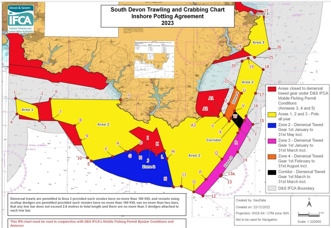
The area covers around 450km2 of the marine area off the coast of South Devon, including recently designated Marine Protected areas (MPAs).
|
The South Devon Inshore Potting Agreement (IPA) was originally a Gentlemen's Agreement and represents one of the most innovate forms of fisheries management in the UK; a management regime with fishermen at it's heart.
In the late 1960s/early 1970s, after a period of technological innovation which enabled fishermen to travel further offshore, fishermen across South Devon found themselves in conflict over access to fishing grounds. By working together to devise zoned access, the fishermen of this period ensured that both mobile and static gear sectors were able to co-exist. In 2002, the IPA was made into law and is now detailed on a fishing vessel's 'licence to fish'. A licence condition to abide by this agreement means that any breaches can be investigated and legal action can be taken. The terms of the IPA are discussed and agreed annually at a meeting between fishermen and regulators; the only example of this kind of management in the UK. The IPA boasts two nature conservation designations - it forms part of the Start Point to Plymouth Sound Special Area of Conservation (SAC) and the Skerries Bank and Surrounds Marine Conservation Zone (MCZ). |
|
Scroll down for download
|
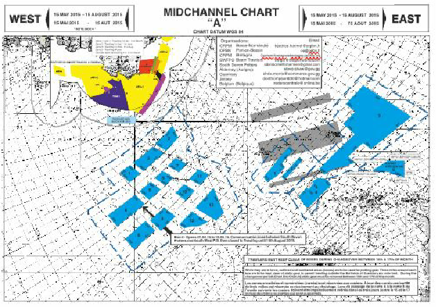
Mid channel blocks:
|
During the late 1970s, technology had continued to develop, enabling local boats to travel some miles offshore and into neighbouring waters. Drawing on the experience with the IPA, fishermen opened discussions with European counterparts, debating access and eventually deciding to share prime fishing grounds in the mid-channel between sectors. Uniquely in the UK, the collaboration means that for part of the year, areas in the mid channel are set aside purely for crab fishing and at other times trawling on an entirely voluntary basis. Scroll down for download
|
Lyme bay: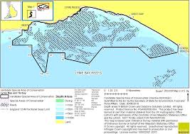
|
The mentioned changes in technology brought about gear conflict that affected the entire South coast potting fleet. SD&CS members local to the Lyme Bay area lobbied various regulators and legislators to suspend access to the inshore areas for the new and visiting mobile gear vessels that were over 12m in length. Conflict continued until, after a series of meetings between static and mobile gear fishermen, a voluntary agreement was eventually reached. As with the IPA, the voluntary agreement was breached on numerous occasions - 15 years of lobbying followed and culminated in hand delivery of a petition to Number 10 by one of our members, which called for further marine protection measures. Working with Dorset Wildlife Trust and with the support of MP's, national marine protection measures were eventually brought in in the form of the Lyme Bay Order- and now Lyme Bay is protected as a Special Area of Conservation. You can find out more about it though the Blue Marine Foundation.
|
SKIPPER INFO:
For vessels fishing outside 6nm, please be aware that both the Mid Channel Blocks and IPA charts should be viewed.
Downloads
MID CHANNEL POTTING BLOCKS:
2024- There have been no changes to the charts.
Chart A will contain crabbing gear May 15 - August 15. (East and West)
Chart B will contain crabbing gear August 15 - December 15 (East) and August 15 - May 15 (West)
**Please be aware that during ''chanegover'' crabbers have three days to move gear - from midnight at the 15th, to midnight of the 17th, as detailed in the information boxes of the PDF chart versions, meaning that there will likely be crabbing gear between Charts A and B for those dates**.
Please see PDF's for more details:
| 2024_mid_channel_chart_a.pdf |
| 2024_mid_channel_chart_b.pdf |
Download digital charts for MaxSea V12:
| PTF (for MaxSea V12) Chart A |
| PTF (for MaxSea V12) Chart B |
**New for 2023** Download digital chats for Turbowin/Sodena plotters
| turbowin__sodena_mid_channel_blocks.zip |
All digital formats:
| all_digi_chart_files.zip |
Additional formats in the zip file for download -
.tzd for TimeZero software (colored surfaces and lines);
. gpx the standard file format for storing coordinate data (colored tracks);
.shp the standard file format for geographic information systems software (colored lines).
The electronic charts were created with TimeZero in WGS84. An offset of about 300 m has been found between the Decca grids of the TimeZero, Maxsea V12 and TurboWin softwares, whereas there is no difference between the Latitude / Longitude grids of these two softwares. As a result, the limits imported into Maxsea V12 have the same GPS position and are positioned at the same location on the marine card but have an offset of about 300 m with the Decca curves displayed
INSHORE POTTING AREA (IPA):
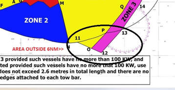
The IPA is regulated by both the Marine Management Organisation (MMO) and Devon and Severn IFCA, owing to the fact that it straddles the 6nm boundary. For ease, we have added the positions of the area outside 6nm to a table below. This is not the entire IPA - details of the whole area can be found in full within the Mobile Gear Permit Annexes, at this link or you can download the visual representation on the PDF below. Please be aware that these positions have been created using the WGS84 datum.
Co-ordinates for IPA outside 6nm:
Point |
Latitude |
Longitude |
11 |
50 o 06.165 N |
003 o 41.806 W |
O |
50 o 05.600 N |
003 o 39.750 W |
12 |
50 o 05.201 N |
003 o 38.301 W |
13 |
50 o 07.251 N |
003 o 35.500 W |
13a |
50 o 07.368 N |
003 o 35.373 W |
| south-devon-trawling-and-crabbing-ipa-chart-and-positions-2024.pdf |
LYME BAY RESERVE:Details of the Lyme Bay Order available here.
|
|